Cyclone and Storm Season

-
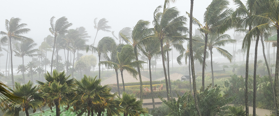
Tropical cyclones are low pressure systems in the tropics that, in the southern hemisphere, have well-defined clockwise wind circulations with a region surrounding the centre with gale force winds (sustained winds of 63 km/h or greater with gusts in excess of 90 km/h). The gale force winds can extend hundreds of kilometres from the cyclone centre. If the sustained winds around the centre reach 119 km/h (gusts in excess of 170 km/h), then the system is called a severe tropical cyclone. These are referred to as hurricanes or typhoons in other countries.
The circular eye or centre of a tropical cyclone is an area characterised by light winds and often by clear skies. Eye diameters are typically 40km but can range from under 10km to over 100km. They eye is surrounded by a dense ring of cloud about 16km high known as the eye wall which marks the belt of strongest winds and heaviest rainfall.
Tropical cyclones derive their energy from the warm tropical oceans and do not form unless the sea-surface temperature is above 26.5°C, although, once formed, they can persist over lower sea-surface temperatures. Tropical cyclones can persist for many days and may follow quite erratic paths. They usually dissipate over land or colder oceans.
Most of the northern coastline of Australia is covered by the Bureau of Meteorology's weather watch radar network. Real time images and information about the weather watch radar can be found at www.bom.gov.au
Tropical Cyclone Outlook
Outlook statements are issued daily by each Tropical Cyclone Warning Centre. These present 3-day outlooks on possible tropical cyclone development in the region and surrounding oceans.
Tropical Cyclone Information Bulletins
Bulletins are issued every six hours if a tropical cyclone exists within the Australian region, but is not expected to threaten any coastal or island communities within the next 48 hours. Bulletins include the cyclone's name, current location and its forecast movement.
Tropical Cyclone Watch
A watch is issued every six hours when there are indications that gales or stronger winds are expected to affect coastal or island communities within 48 hours but not within 24 hours. It details the communities expected to be affected and gives a brief estimate of the cyclone's location, intensity, severity category and movement.
Tropical Cyclone Warnings
A warning is issued every three hours when there are indications that gales or stronger winds are expected to affect coastal or island communities within 24 hours. As well as information provided in a watch advice, warning advices also inform of expected maximum wind gusts. Forecasts of heavy rainfall, flooding and abnormally high tide are including where necessary. Communities under threat are also advised to take precautions necessary to safeguard their lives and property. When a cyclone is under radar surveillance close to the coast, hourly advices may be issued.
The general name given to Tropical Cyclone Watch or Warning messages is an Advice or Tropical Cyclone Advice. A tropical cyclone advice is prefixed "FLASH" when it is the first warning to a community not previously alerted by a cyclone watch. It is also issued when major changes are made to the previous warning due, for example, to unexpected movement towards the coast or rapid intensification.
Standard Emergency Warning Signal
The Standard Emergency Warning Signal is an audible signal that is sounded to broadcast media in an emergency situation to gain public attention. This would typically occur in an area where a tropical cyclone of category 2 or stronger is expected to affect a community within 12 hours.
Tropical Cyclone Track and Threat Maps
Track maps are designed to visually complement information contained in watch and warning advices. They show the past track of the cyclone, with distinctive colours or shades to depict watch and warning zones.
(This map is a correct and current version as supplied by Emergency Management Queensland in January 2012. For possible updated versions it is recommended that you check the Queensland Fire and Emergency Services website)
Cyclone tracking maps can also be found at www.bom.gov.au
-
Categories of cyclone severity range from 1 for weak cyclones to 5 for the most severe cyclones.
Category Average wind (km/h) Strongest Gust (km/h) Central Pressure (hPa) 1 63-90 Less than 125 Greater than 985 Typical effects (indicative only): Negligible house damage. Damage to some crops, trees, caravans. Craft may drag moorings.
Category Average wind (km/h) Strongest Gust (km/h) Central Pressure (hPa) 2 90-120 125-170 985-970 Typical effects (indicative only): Minor house damage. Significant damage to signs, trees, caravans. Heavy damage to crops. Risk of power failure. Small craft may break moorings.
Category Average wind (km/h) Strongest Gust (km/h) Central Pressure (hPa) 3 120-160 170-225 970-945 Typical effects (indicative only): Some roof and structural damage. Some caravans destroyed. Power failures likely.
Category Average wind (km/h) Strongest Gust (km/h) Central Pressure (hPa) 4 160-200 225-280 945-920 Typical effects (indicative only): Significant roofing loss and structural damage. Many caravans destroyed and blown away. Dangerous airborne debris. Widespread power failures.
Category Average wind (km/h) Strongest Gust (km/h) Central Pressure (hPa) 5 More than 200 More than 280 Below 920 Typical effects (indicative only): Extremely dangerous with widespread destruction.
An estimate of cyclone severity is now included in all tropical cyclone advices. The tables above provide information concerning effects due to wind, which are typical of cyclones in the various categories. Remember that the system is not designed to give an exact statement of conditions at inpidual locations but will give a general idea of the expected worst conditions.
Cyclone Movement
Research has shown that cyclones in the Australian region exhibit more erratic paths than cyclones in other parts of the world. A tropical cyclone can last for a few days or up to two or three weeks. Movement in any direction is possible including sharp turns and even loops.
Never Become Complacent
Even if previous cyclones have not moved over your area this is no guarantee that future cyclones will also miss you.
-
- Check with the Cassowary Coast Regional Council to see if your home has been built to cyclone standards.
- Check that the walls, roof and eaves of your home are secure.
- Trim treetops and branches well clear of your home (get Council permission).
- Preferably fit shutters, or at least metal screens, to all glass areas.
- Clear your property of loose material that could blow about and possibly cause injury or damage during extreme winds.
- In case of a storm surge/tide warning, or other flooding, know your nearest safe high ground and the safest access route to it.
- Check neighbours, especially recent arrivals, to make sure they are prepared.
Prepare an emergency kit including:
- A portable battery radio, torch and spare batteries
- Water containers, dried or canned food and a can opener
- Matches, fuel lamp, portable stove, cooking gear, eating utensils
- A first aid kit and manual, masking tape for windows and waterproof bags
- A list of emergency phone numbers
-
If your boat is on a trailer
- Remove the outboard, safety equipment, radios, sounders, bimini covers and any other items that are valuable or may be blown away or damaged by the wind.
- Remove it from the trailer, placing it on the ground facing the direction the wind will come from, and lash it with 24mm rope or chains to ground anchors or the most secure object available. Place the boat away from trees or objects that may fall on them.
- Half fill the boat with water, except for stern drive or inboard motored boats.
- If you cannot remove the boat from the trailer, turn the boat to face the wind, let the air partially out of the tyres and place wooden blocks between the frame member and the axle inside each wheel. Lash it with 24mm rope or chains to ground anchors or the most secure object available. Place the boat away from trees or objects that may fall on them.
- Filling a boat on a trailer with water may break your trailer springs and axles wedges should be forced into the springs to distribute the additional weight on the axle.
If your boat is in the water
- Contact your local Coastguard, Volunteer Marine Rescue Unit, Marine Watch or Harbourmaster to find out where the designated safe anchorages are in your area and any cyclone plans that may be in place.
- Know your marina's cyclone plan – particularly if they require you to remove your vessel.
- Ensure that your boat can reach the safe anchorage remembering that tides may be higher then normal – make a trial run at the beginning of the cyclone season.
- See the Johnstone River Cyclone Contingency Plan. For more information about the plan, go to the Maritime Safety Queensland website.
Moored boats
- Double all ties.
- Make ties high on pilings to allow for rising waters.
- Cover all tie lines at contact points with rubber or other materials to prevent chafing.
- Install fenders to protect the boat from rubbing against the dock or mooring.
- Be sure batteries are sufficient to run bilge pumps throughout the storm.
- Put duct tape on windows and hatches.
- Insert plugs in engine ports.
- Strip bimini tops, sails or any other object that could blow away.
- Disconnect shore power.
- Close fuel valves and cockpit seacocks.
-
When a Cyclone Watch is Issued
- Re-check your property for any loose material and tie down (or fill with water) all large, relatively light items such as boats and rubbish bins.
- Fill vehicles’ fuel tanks. Check your emergency kit and fill water containers.
- Ensure household members know which is the strongest part of the house and what to do in the event of a cyclone warning or an evacuation.
- Turn to your local radio/TV for further information and warnings.
- Check that neighbours are aware of the situation and are preparing.
When a Cyclone Warning is Issued
- Collect children from school or childcare centre and go home.
- Park vehicles under solid shelter (hand brake on and in gear).
- Put wooden or plastic outdoor furniture in your pool or inside with other loose items.
- Close shutters or board-up or heavily tape windows. Draw curtains and lock doors.
- Pack an evacuation kit of warm clothes, essential medications, baby formula, nappies, valuables, important papers, photos and mementos in waterproof bags to be taken with your emergency kit. Large/heavy valuables could be protected in a strong cupboard.
- Remain indoors (with your pets). Stay tuned to your local radio/TV for further information.
When a Local Evacuation Warning is Issued
- Based on predicted wind speeds and storm surge heights, evacuation may be necessary. Official advice will be given on local radio/TV regarding safe routes and when to move.
- Wear strong shoes (not thongs) and tough clothing for protection.
- Lock doors; turn off power, gas, and water; take your evacuation and emergency kits.
- If evacuating inland (out of town), take pets and leave early to avoid heavy traffic, flooding and wind hazards.
- If evacuating to a public shelter or higher location, follow police and State Emergency Services directions.
- If going to a public shelter, take bedding needs and books or games for children.
- Leave pets protected and with food and water.
-
- Disconnect all electrical appliances. Listen to your battery radio for updates.
- Stay inside and shelter (well clear of windows) in the strongest part of the building, ie cellar, internal hallway or bathroom.
- Keep evacuation and emergency kits with you.
- If the building starts to break up, protect yourself with mattresses, rugs or blankets under a strong table or bench or hold onto a solid fixture, eg a water pipe.
- Beware the calm “eye”. If the wind drops, don’t assume the cyclone is over, violent winds will soon resume from another direction. Wait for the official “all clear”.
- If driving, stop (handbrake on and in gear) – but well away from the sea and clear of trees, power lines and streams. Stay in the vehicle.
-
- Don’t go outside until officially advised it is safe.
- Check for gas leaks. Don’t use electric appliances if wet.
- Listen to local radio for official warnings and advice.
- If you have to evacuate, or did so earlier, don’t return until advised. Use a recommended route and don’t rush.
- Beware of damaged power lines, bridges, buildings, trees, and don’t enter floodwaters.
- Heed all warnings and don’t go sightseeing. Check/help neighbours instead.
- Don’t make unnecessary telephone calls.