Disaster & Emergency
-
What is a storm tide?
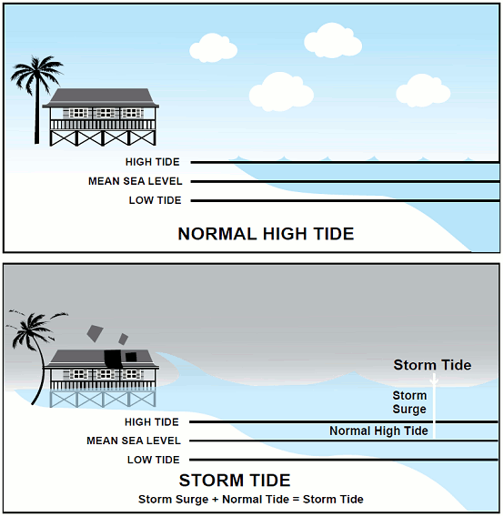
A storm tide is a rise above the normal water level, along a shore, that is the result of a tropical cyclone.
When a cyclone forms over open waters the strong winds pushing the water, combined with the low atmospheric pressure in the eye of the cyclone, cause the level of the sea to rise.
This results in the formation of large waves.
If this happens away from land, the water can escape and move freely away from the building storm. As the cyclone moves towards land and the depth of the water becomes shallower, the ever-increasing wall of water does not have a chance to flow away. These large waves may inundate land and cause destructive damage to anything in their path.
Please note that inundation by storm tide is not comparable with riverine flooding.
Storm tides will be accompanied by gale force winds, with successive waves of seawater rapidly moving across the foreshore. Trees, building material and other debris may be carried along by the storm tide.
Any evacuation must occur before the storm tide event.
A storm tide event should not be confused with a tsunami. A tsunami is a series of waves generated by a sudden upward movement of the ocean floor, normally due to earthquakes and is NOT related to a cyclonic event.
What if I am in an Evacuation Zone?
If your property is located in an evacuation zone, you need to read this information. It is important to understand what you need to do in the event of a storm tide.
Identify where your residence is located on the evacuation map and familiarise yourself with your evacuation zone and routes.
If you are in a red, orange, yellow or blue zone, there is a chance that your property may be inundated in a storm tide event. The height of the predicted storm tide during the disaster event will determine which zones are affected.
If you are not located in a coloured zone, you are outside the storm tide inundation threat area.
How to read and the use the storm tide evacuation maps
- Identify where your residence is located on the map.
- If you are in one of the coloured zones, you may be at risk from storm tide inundation.
- Identify your evacuation route to your pre-determined safer location.
- During a cyclone event tune in to warnings. You can hear them on local radio stations i.e. ABC Far North and Radio 4KZ. Authorities will advise which zones need to evacuate.
Evacuation Zones
What do storm tide evacuation zones mean?
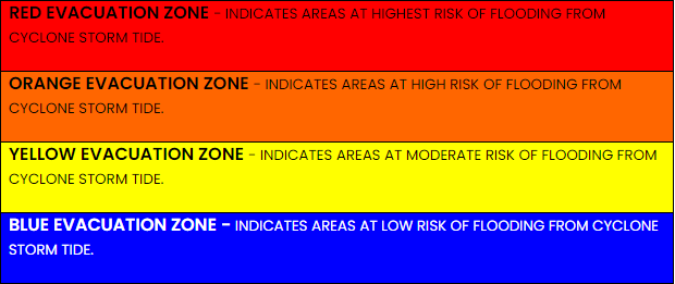
Residents in the Red Zone face the highest risk of inundation from a cyclone storm tide. The Red Zone includes low-lying coastal areas and populations at greater risk.
Residents in the Orange Zone face a high risk of inundation from a cyclone storm tide. The Orange Zone may experience storm tide inundation during moderate events.
Residents in the Yellow Zone face a moderate risk of inundation from a cyclone storm tide. The Yellow Zone may experience storm tide inundation during larger events.
Residents in the Blue Zone face a low risk of inundation from a cyclone storm tide. The Blue Zone may experience storm tide inundation during the most significant events.
-
Cassowary Coast region storm tide evacuation maps have been endorsed by the Cassowary Coast Regional Council for publication and comment. Please fill in the Comments Form at the bottom of this page after viewing the maps and information.
For more information on disaster management planning, please refer to the Queensland Fire and Emergency Services website.
Storm Tide Maps
- Regional Overview (Key Map)
- Map 1 - Innisfail
- Map 2a - Mourilyan
- Map 2b - Mourilyan Harbour
- Map 3 - Cowley
- Map 4 - Maria Creek (Kurrimine to Bingil Bay/Narragon)
- Map 5 - Mission Beach
- Map 6a - Euramo
- Map 6b Tully/Hull Heads
- Map 7 Bilyana
- Map 8 Kennedy
- Map 9 Cardwell
- Map 10 Damper Creek
- Map 11 Rungoo
-
Please click on the following links for fact sheets in a number of different languages:
- Preparing Your Home Factsheet - English
- Preparing Your Home Factsheet - Hmong
- Preparing Your Home Factsheet - Vietnamese
- Preparing Your Home Factsheet - Indonesian
- Preparing Your Home Factsheet - Italian
These factsheets are correct and current versions as supplied by Emergency Management Queensland in January 2012. For possible updated versions it is recommended you check Queensland Fire and Emergency Services website.
-
Your emergency kit should be stored in your house and ready for any event.
It should include:
- Battery-operated radio
- Torch & spare batteries
- Candles, lighter & waterproof matches
- First-aid kit and manual
- Combination pocket knife
- Portable (gas) stove with fuel
- Cooking gear
- Water in sealed containers (10 litres per person)
- Medication including additional supplies
- Toiletry & sanitary supplies
- Change of clothes & strong shoes
- Non-perishable food (cans) - enough for 3 - 4 days plus can opener & utensils
- Special needs items for young children, the aged & people with disabilities
- Pet food, water & other animal needs
- Tent or tarpualin & blankets
- Other camping equipment
- Cash money (ATMs may not be available after an event)
- Personal documents (insurance certificates, photographs etc.)
- Strong plastic bags (for clothing & valuables)
- List of emergency phone numbers
Store these items in one or two sturdy, easily-transportable bags or boxes.
-
Has your business been affected by the recent March flood event? The Queensland Government is undertaking a survey to assess the impact of a natural disaster on the affected businesses and the regional economy.
Visit the Natural Disaster Business Survey.
Preparation is the key to survival and the Cassowary Coast Regional Council takes the matter of disaster management, recovery and resilience seriously.
The Far North Queensland region can experience severe climatic conditions, which can lead to potential business losses. The Cassowary Coast Regional Council is an experienced manager of major disaster events and, as such, wishes to ensure that the region's businesses are well prepared for any event.
To make your business more resilient Council encourages thorough planning and preparation. This will minimise the possibility of damage, interruptions and the loss of business if and when disaster strikes. Council does not enforce business preparation and mitigation activities but encourages and promotes good business practice throughout the region. Council recommends that all businesses, regardless of size, develop a business continuity and recovery plan to deal with any threat.
The Queensland and Australian Government, along with many other organisations, provide substantial help to businesses on an ongoing basis. Below is a sample of support information available to businesses, including business continuity templates.
Queensland Government
Australian Government
Other Sources of Information
-
Public cyclone shelters are buildings that have been purpose built to provide a place of refuge for residents who live in storm surge evacuation zones. The shelters have very limited capacity so they should not be the first sheltering option and are only for those that have exhausted all other options.
On the Cassowary Coast we have two purpose-built cyclone shelters which are located in Tully and Innisfail.
The shelters are intended to be a short-term option of up to around 18 hours and have very basic amenities. Evacuees will only have about one square metre of seating space and all belongings (including food, water, medications and clothing) must be contained in a small bag which will fit under a seat.
There will be no cooking facilities available for use nor will any be allowed to be brought in. There will be no food available and for the safety of everyone within the shelter, no pets will be permitted.
The public cyclone shelters are not pleasant places to be as they are usually cramped, uncomfortable and most likely very noisy and hot. Conditions can be compared to sitting on a domestic airline flight where you have little room to move and limited ability to walk around.
Under the conditions of entry no alcohol, cigarettes or other prohibited items are permitted into the shelter and there is a strict code of conduct which must be complied with by all evacuees.
If everyone has the cyclone shelters as their first option, they will fill quickly and leave other residents with nowhere to go. For this reason, all residents must plan for what they will do if they need to evacuate their home. A public cyclone shelter should not be any of the primary shelter options.
Residents who need to evacuate will be much more comfortable sheltering with family or friends in their homes in a safer location or leaving the area completely. Residents will also be more comfortable sheltering in hotel or motel accommodation outside of the warning area.
Don't wait until it's too late get ready now.
-
The best address in a disaster
For live, up-to-the-minute updates on power outages, weather warnings, road conditions, and more - head to disaster.cassowarycoast.qld.gov.au, and stay informed.
Cassowary Coast Disaster Dashboard
FloodInform Report
Information supplied on this website, discover.cassowarycoast.qld.gov.au, can be one of your first steps to becoming prepared.
If your area of interest is part of the flood study area, the flood maps at the above website can show whether you live or work in a flood-prone area. You can follow the links on the website to find out about how you can prepare and protect yourself, your family and home.
The new FloodInform System is an initiative of Cassowary Coast Regional Council.
The maps show the estimated areas of inundation for a variety of flood events.
Flood analysis is based on comprehensive computer modelling calibrated against records of actual flood events.
The website provides locations, street names, aerial photography and available flood mapping for defined areas of the Cassowary Coast region.
Cassowary Coast Regional Council Flood Study 2014
The study documents the update of the Tully/Murray and Johnstone River flood models and the creation of new models for the Moresby, Liverpool, Maria and Banyan/Bulgun Creeks. Using udpated flood modelling results, development planning controls have been defined for the Cassowary Coast Regional Council limits.
Johnstone River Flood Study 2003The study area is confined to the lower reaches of the Johnstone and South Johnstone Rivers, covering towns of Innisfail, South Johnstone, Wangan, Mourilyan and surrounds.
Johnstone River Flood Study Vol 1 (1 MB)
Johnstone River Flood Study Vol 2 part 1
Johnstone River Flood Study Vol 2 part 2
Johnstone River Flood Study Vol 2 part 3
Johnstone River Flood Study Vol 2 part 4
Johnstone River Floodplain Management Plan 2003 (3.11 MB)
Former Cardwell Shire - Flood & Storm Surge Study
The Flood Study area includes the Tully and Murray River Catchments from Tully in the north to Cardwell in the south and areas in between.
Cardwell Inundation Study 2008 part 1
Cardwell Inundation Study 2008 part 2
Cardwell Inundation Study 2008 Drawing Addendum Part 1
Cardwell Inundation Study 2008 Drawing Addendum Part 2
Cardwell Inundation Study 2008 Drawing Addendum Part 3
Cardwell Inundation Study 2008 Drawing Addendum Part 4
Cardwell Inundation Study 2008 Drawing Addendum Part 5
Flood Evacuation Maps
Flood Evacuation Maps for the Innisfail area have recently been prepared by the Cassowary Coast Regional Council. Other areas will be added progressively as mapping is finalised.
Innisfail (East) Evacuation Zones
Innisfail (West) Evacuation Zones
For more information on Disaster Manager Planning, please refer to the Emergency Services Queensland website.
Local Drainage Studies
Council has undertaken a number of local drainage studies in urban areas. The studies assess our network's drainage capacity, compare it to current standards, identify solutions for drainage issues and help in the design of replacement infrastructure.
The studies and drainage models also allow developers and their engineers to assess any impacts of proposed developments. To access Council's flood or drainage models, consulting engineers need to complate a data share agreement and pay a data management fee.
In the studies, Council prioritises drainage upgrade options and determines a priority order for stormwater upgrade works throughout the region. Projects are undertaken as funding becomes available in annual Council budgets.
The studies that have been undertaken include:-
- Cardwell
- Innisfail CBD
- Innisfail East
- Innisfail Estate
- Mission Beaches
- Mourilyan
- Silkwood
- South Johnstone
- Tully-Hull Heads
View and Download Reports and Drawing Addendums.
-
What to do
- Meet with your family and explain the need for a Family Disaster Plan. Explain to all members, including children, the likely threats and the dangers of each.
- Explain to each family member what he or she should do during a disaster event.
- As a family locate a safe place in your house to shelter for each type of hazard.
- Designate a friend or relatives house as an alternative shelter if a member of your family is unable to make it home when a hazard threatens or you are not allowed to return to your house due to an evacuation of your area. This should also be the place you self evacuate to in the event your area has to be evacuated. All family members should know the name of the occupants, their address and telephone number. If you have pets ensure that you can bring your pets as well.
- Develop an emergency communications plan. In the event that family members become separated, as can happen with the swift onset of an event such as flooding during the day when parents are to work and children at school, have a plan for getting back together.
- Arrange for an out of town relative or friend to be your family contact point. This is the person, living well away from you, who you will contact to provide information on how you have fared during the disaster and the condition of the family. This person will then inform all other relatives and friends of your situation. They also become the focal point for inquiries as to your welfare from others.
- Make sure every family member has a clear idea of what will be required if an evacuation notice is issued. What they must do and what the family must do to make their way to safety.
- Produce check-lists of action to take in preparation for specific disaster events.
- Place emergency telephone numbers clearly near the phone. Teach children to ring 000 in an emergency.
- Create an Emergency Kit
- Document your Family Disaster Plan and practice it with the whole family.
Further Information
Educate Your Children
- Tell children that a disaster is something that happens that could hurt people, cause damage, or cut off things such as electricity, water and telephones. Explain to them that nature sometimes provides “too much of a good thing” such as rain, wind and fire. Talk about things that the children can relate to such as loss of power or no water. Watch television programs on natural hazards with them and explain that is what can happen and discuss with them their impressions.
- Give examples of disasters that could happen in your area. Help children recognise the warning signs of the disaster that could affect your community. Talking about disaster, with them, ahead of time will reduce the fear and anxiety when an event does occur and lets them know how to respond.
- Teach your children how to ring 000 in a life threatening emergency or when parents are incapacitated.
- Have your children undertake a first aid or CPR course.
- Tell children about the many people who will help them during a disaster. Explain the roles of the various emergency services and support agencies and how your children can identify them.
- Teach your children to call the family contact if they become separated during a disaster event. Help them memorise the telephone number or give it to them on a card they can keep with them
Remember Your Pets
Prepare your pet for disasters
- Check with animal refuges, animal boarding facilities, vets and Council on whether they can provide accommodation for your pets in the event of an evacuation.
- Contact hotels and motels outside of the threat area and check on their policies for accepting pets and any restrictions on size, species etc. Ask if pet policies can or will be waived during disaster events.
- Make arrangements to board your pets at an animal boarding facility for the duration of the event.
- Check with vets, RSPCA, animal welfare groups and Council to identify if any Emergency Pet Shelters are to be established during disaster events. Add the contact details to your emergency contact list.
- Ask friends or relatives outside of the affected area to house and care for your pets. Preferably this should be the place that you have self evacuated your family to.
- Buy a pet carrier that allows your pet to stand up and move around. Make sure your pet is comfortable with the carrier by training them to enter and spend time in it.
Need a pet carrier?
If you do not have a pet carrier small to medium animals can be carried in their cages, pillowcases or in secure boxes with air holes.
- Check with your local pet store for a small tank to transport your fish in with attached battery operated aerator. A battery operated aerator, and bucket, of the type used by fisherman to keep live bait alive will also be adequate. If you have no other option put your fish into a large wide necked jar, two-thirds filled, with a secure lid and aerate by gently blowing through a straw. Remove the lid when stationary to allow for some air saturation.
- Frogs need a small covered container with 2.5cm of water in the bottom and airholes in the top.
- Snakes and lizards need to be put in a container with a secure lid and airholes, or a sack/pillowcase.
Before an event
If your pet is on medication ensure you have an adequate supply to cover a disaster event.
- Have your pet wear an identification tag listing your name, address and telephone number.
- If your pet normally wears a choker collar have a separate leather or nylon collar available for wear during disaster events. This is to ensure no injury is caused to your pet during stressful conditions.
- Keep your pet’s immunisation shots up to date and have all records available to take with you if you have to evacuate. Boarding facilities, Emergency Animal Shelters, etc will not take pets without records of immunisations.
- In your family emergency kit have extra supplies of dry pet food, kitty litter, food and water feeders/containers and extra mediation.
- Consider a muzzle for your dog, as the stress of disaster events will affect animals as well leading to normally placid animals becoming aggressive.
- Have recent photos of pets available to help with identification in the event you become separated from them.
Leaving your pets behind
If you have to leave pets behind when you evacuate consider the following:
- Place each pet in a separate room. Even pets that normally get on well together may become aggressive towards each other under the stress. Do not tie them up.
- Leave their normal bedding with them as well as any favourite toys to help control any anxiety being felt by your pets.
- Small rooms, without windows, which are easy to clean such as toilets and bathrooms are most appropriate.
- If there is a threat of flooding or storm surge leave chairs, tables, benches etc which will allow your pet to gain height.
- Leave two or three days of dry food in a large heavy container that is difficult to knock over.
- Leave water in a sturdy container that is difficult to knock over. A tap left slowly dripping can replenish water supplies in a container and large dogs may be able to drink from a partially filled bathtub.
- Birds must eat daily to survive. Check with your vet on suitable food dispensers that regulate supply.
- Leave a notice on the outside and inside of your door advising emergency services personnel of which animals they are likely to encounter and in which rooms. Also leave the details of where you can be contacted.
After an event
- After the event, if you cannot return to your home, contact Council to find out what arrangements have been made to reunite pets with owners.
- If you have to leave the area after a disaster event take your pets with you, as they cannot survive without you.
- Keep them leashed and in close contact with you for a period after the event until they settle into their new surroundings and routine.
- The behaviour of pets can change remarkably after a disaster event. Be alert to changes and seek advice from the vet as necessary.
-
Before a flood
- Listen to your radio.
- Heed all warnings and advice.
If a flood comes
- Collect your emergency evacuation kit and listen to the radio for official advice.
- Anchor down anything which might float away.
- Switch off electricity and gas if you must leave home.
- Avoid entering flood waters on foot or in a vehicle.
- DO NOT drink flood waters.
- DO NOT attempt to cross a flowing stream on foot if the water is above your knees.
- If driving, know the depth of the water in a dip before crossing. The road may not be intact under the water.
- A stalled vehicle can be swept away by rapidly rising water. Abandon the vehicle if necessary.
- Avoid travelling long distances, motorists can be stranded for days at a time.
After the flood
- If you had to evacuate, DO NOT return home until advised, then use the route recommended.
- Continue to listen for additional weather warnings and advice.
- Help injured or trapped neighbours.
- Be wary of fallen power lines, damaged buildings, unstable tree branches, and hidden dangers associated with any flooding.
- Electrical equipment that has been water damaged should be dried and checked by a qualified electrician before use.
- When entering buildings use extreme caution.
- Check the fridge and freezer for spoilage.
- Do not drink or prepare food with tap water until advised by Cassowary Coast Regional Council that supplies are safe for consumption.
- Throw away any food that has come into contact with flood waters.
- Pump out flooded basements gradually to avoid structural damage.
- Repair damaged septic tanks, cesspools, pits and leaching systems as soon as possible as they pose a health hazard to yourself, your family and your neighbours.
- Use the telephone only for emergency calls.
Preventative measures
- By being aware and taking preventative measures before a flood eventuates, the negative effects of a flood can be lessened.
- Check your local flood history or flood plans through Council. Avoid building on floodplains unless you elevate and reinforce your home.
- If you area is flood prone, consider alternatives to carpet on ground levels, such as removable floor rugs, and tiled floors and walls.
- Keep insurance policies, documents and other valuables in a watertight container stored in a high place in your house. You will need your personal papers after the impact to ensure speedy insurance claims and to access bank accounts, etc. Do not forget to take the container with you if you have to evacuate.
- Raise your electrical panel to a high position above flood level.
- Install check valves in sewer traps to prevent floodwater from backing up into the drains of your house. This will prevent raw sewage from contaminating your house.
- Construct floodwalls to stop floodwater entering your home. You will need to check with Council Engineering Staff to confirm the regulations pertaining to the construction of floodwalls and levees in your area. You may not be allowed to build a floodwall in your area.
- Seal walls in basements, or those regularly exposed to flooding, wither waterproofing compounds to prevent seepage through cracks.
- Have a builder add a waterproof veneer to exterior walls of your house.
- Keep a supply of sandbags, and sand to fill them with, available to sandbag doors to prevent water from entering your house.
- List emergency phone numbers in a clearly visible location.
- Prepare an emergency kit.
- Do not camp in dry river beds as they can become flooded without warning.
-
Some landslides move slowly and cause damage gradually, others move so rapidly that they can destroy property and take lives suddenly and unexpectedly. Gravity is the force driving landslide movement. Factors that allow the force of gravity to overcome the resistance of earth material to landslide movement include saturation by water, steepening of slopes by erosion or construction and earthquake shaking.
Landslides are typically associated with periods of heavy rainfall and tend to worsen the effects of flooding that often accompany these events. In areas burned by bushfire a lower threshold of rainfall may initiate landslides.
Debris flows, sometimes referred to as mudslides, are common types of fast moving landslides. These flows generally occur during periods of intense rainfall. They usually start on steep hillsides as shallow landslides that liquefy and accelerate to speeds that are typically about 16kph, but can exceed 50kph. The consistency of debris flows ranges from watery mud to thick, rocky mud that can carry large items such as bounders, trees and cars. Debris flows from many different sources can combine in channels, and their destructive power may be greatly increased. They continue flowing down hills and through channels, growing in volume with the addition of water, sand, mud, boulders, trees and other materials. When the flows reach flatter ground, the debris spreads over a broad area, sometimes accumulating in thick deposits that can wreak havoc in developed areas.
Preventative Measure and Warning Signs
- Learn about the landslide risk in your area.
- Develop an evacuation plan that details which route you will use to escape a landslide and an alternative if your main route is blocked.
- Discuss landslides and debris flow with your family.
- If your property is in a landslide risk area, contact a company specialising in geotechnical engineering, civil engineering or structural engineering for advice on corrective and protective measures you can take.
- Become familiar with the land any structures around you so that you will notice any changes.
- Watch the patterns of storm water drainage on slopes near your home, and especially the places where runoff water converges, increasing flow over soil covered slopes.
- Plant ground cover and build retaining walls to limit the chances of a landslide occurring.
Landslide Warning Signs
- Doors or windows stick or jam for the first time.
- New cracks appear in plaster, tiles, bricks or foundations.
- Outside walls, walks or stairs begin pulling away from the building.
- Slowly developing, widening cracks appear on the ground or on paved areas such as streets or driveways.
- Underground utility lines break.
- Bulging ground appears at the base of a slope.
- Water breaks through the ground surface in new locations.
- Fences, retaining walls, utility poles or trees tilt or move.
- You hear a faint rumbling sound that increases in volume as the landslide nears. The ground slopes downward in one specific direction and may begin shifting in that direction under your feet.
If A Landslide Occurs
If you Suspect an Imminent Landslide Danger
- If you believe there is a real potential for a landslide to occur within a short period of time call the emergency services immediately on 000. If you are unsure or there are no indicators of an immediate threat contact Council immediately.
- Inform affected neighbours. Your neighbours may not be aware of potential hazards. Advising them of a potential threat may help save lives. Help neighbours who may need assistance to evacuate.
- Evacuate. Getting out of the path of a landslide or debris flow is your best protection.
What to do During a Landslide
- Quickly move out of the path of the landslide or debris flow. Moving away from the path of the flow to a stable area will reduce your risk.
- If escape is not possible, curl into a tight ball and protect your head. A tight ball will provide the best protection for your body.
What to do After the Landslide
- Stay away from the slide area. There may be a danger of additional slides.
- Check for injured and trapped persons near the slide, without entering the direct slide area. Direct rescuers to their location.
- Help neighbours who may require special assistance. Elderly people and people with disabilities may require additional assistance. People who care for them or who have large families may need additional assistance in emergency situations.
- Listen to local radio or television stations for the latest emergency information.
- Watch for flooding, which may occur after a landslide or debris flow. Floods sometimes follow landslides and debris flows because they may both be started by the same event.
- Look for and report broken utility lines to appropriate authorities. Reporting potential hazards will get the utilities turned off as quickly as possible, preventing further hazard and injury.
- Check the building foundations and surrounding land for damage. Damage to foundations and the surrounding land may help you to assess the safety of the area.
- Replant damaged ground as soon as possible since erosion caused by loss of ground cover can lead to flash flooding.
- Seek the advice of a geotechnical expert for evaluating landslide hazards or designing corrective techniques to reduce landslide risk. A professional will be able to advise you of the best ways to prevent or reduce landslide risk, without creating further hazards.
-
What to do when you come across an accident/spill involving hazardous materials:
- Beware! An unplanned approach could result in being exposed to hazardous materials.
- Stay upwind and on high ground.
- Notify police and/or fire services.
- Avoid contact with material.
- Stay well away.
What to do when hazardous material accident/spill occurs in your area:
- Stay indoors.
- Close doors and all windows.
- Listen to the radio for further advice.
- Evacuate only when advised by police or fire service personnel.
- Turn off all power.
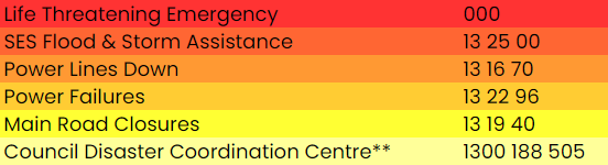
Emergency Contacts
**The Council Disaster Coordination number is activated in times of disasters. Ring for help with water, waste water, council roads, drains, environmental health etc